


Implementing Open Mapping in Municipal Management: Collaborative Public Transport Mapping Project in Zamora
Posted by Mar Marín Villagrana, Codeando México • Sept. 19, 2024
The Rutatón-Zamora project, led by the Mobility Department of the Municipality of Zamora, Codeando México and CoMapper, seeks to collaboratively map public transport routes in Zamora and its neighboring municipalities. With HOT's support, accurate data has been generated on routes and transport units, enabling local authorities to make better-informed decisions to optimize public transport and improve accessibility in the region.
Daniel Acevedo is part of the Mobility Department of the Municipality of Zamora, specifically in the Road Safety and Transport Coordination area. From the municipality, he coordinates the Rutatón-Zamora project, an initiative aimed at collaboratively mapping and tracing public transport routes.
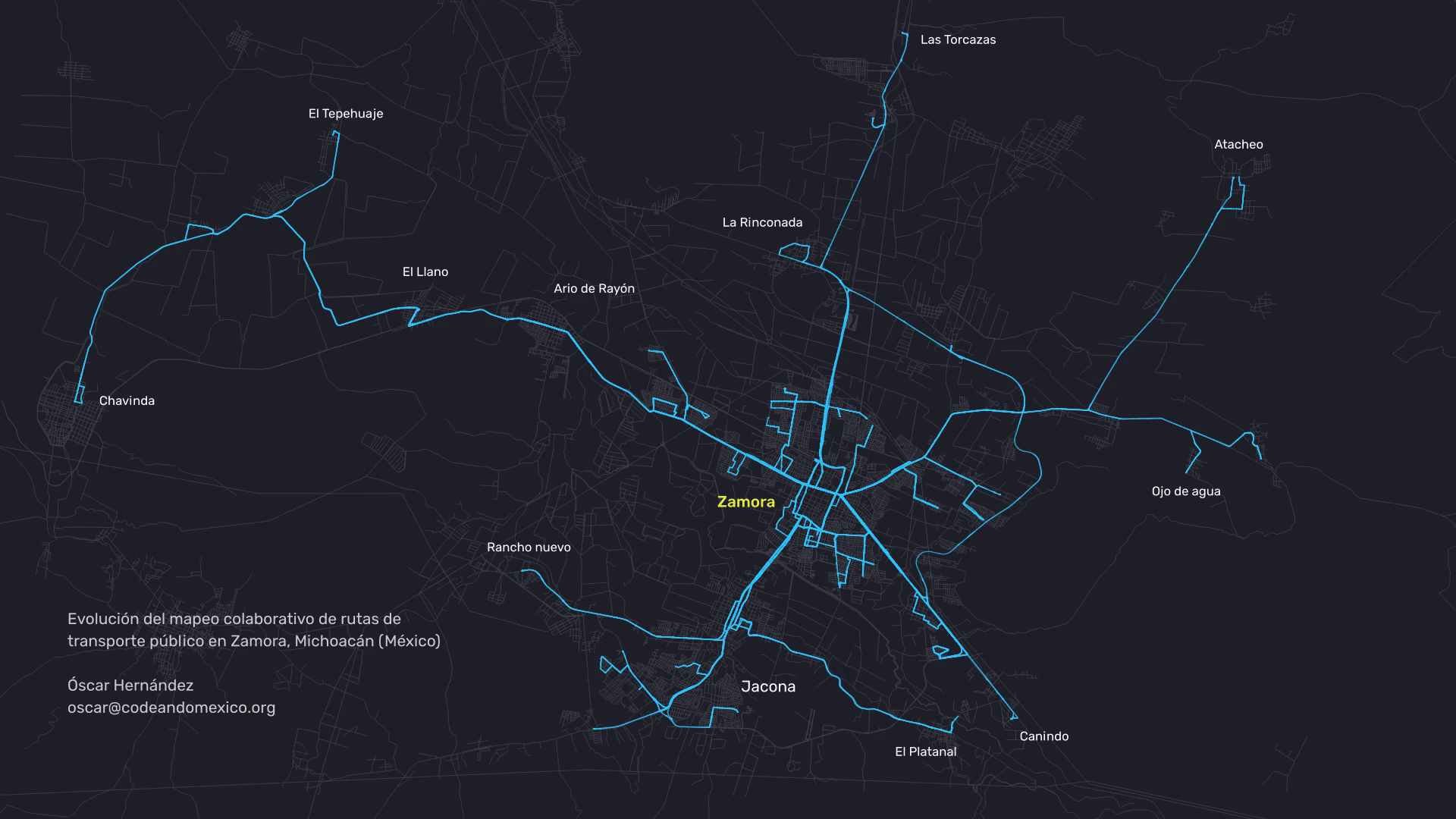
This project, which provides the framework for this reflection, covers the municipalities of Zamora and Jacona, as well as their neighboring communities (Chavinda, Atacheo, El Tepehuaje, Las Torcazas, El Llano, Ario de Rayón, La Rinconada, Rancho Nuevo, El Platanal and Ojo de Agua). It is part of the Humanitarian OpenStreetMap Team (HOT) Resilient Cities Program for Latin America and the Caribbean, which aims to strengthen urban resilience in the region. It is carried out in collaboration with Codeando México and CoMapper, and builds on previous efforts in Michoacán in collaboration with the former COCOTRA, such as the transport mapping in Zitácuaro.
In conversation with Daniel, we explored the Mobility Department's experience implementing these open mapping tools, looking at their prior knowledge, their learning process and how they will apply these tools in future initiatives.
The Experience of the Mobility Department of Zamora, Michoacán
In Zamora, 21.1% of students use public transport, above the Michoacán state average of 19.5%. For this reason, Daniel stresses the need for accurate, well-organized data on the public transport system to support decision-making in the public sector.
Although the team had heard of open mapping tools before, this project marks the first time they have been implemented in the municipality. There was no evidence of previous government use of OpenStreetMap in Zamora.
Daniel says: "The experience was very satisfying; it gave us the knowledge we were looking for to have evidence about public transport. We had a vague idea based on what some operators and concession holders told us, but we didn't know for certain what state the system was in."
The main goal of the collaborative mapping project in Zamora was to develop a clear, detailed map of public transport routes, in collaboration with the Mobility Department of the Municipality of Zamora, Codeando México, CoMapper, HOT and Trufi. Since the municipality had no route map, this effort would allow the information to be organized graphically, benefiting residents, visitors, the tourism sector and the local government itself, so that it can carry out any mobility-related action.
Video: Evolution of the collaborative mapping of public transport routes in Zamora, Michoacán (Mexico), by Óscar Hernández of Codeando México.
The project was made possible by the additional support of seven local university volunteers doing their social service, and six members of the Mobility Department. The synergy between these groups made it easier to trace routes and create maps in OpenStreetMap (OSM), contributing significantly to the mapping and organization of transport information. HOT considers the interaction between public officials and volunteer mappers from civil society in these exercises especially valuable, as it fosters positive cross-learning, both for the data and for civic participation in public policy mechanisms.
The tools used included:
-
OSM via iD Editor and JOSM: As a first step in mapping transport routes, all of the city's streets had to be mapped in OpenStreetMap completely and in detail. This base makes it possible to then add detailed transport information in OpenStreetMap: the information about the route that runs along a street is added to the vector that represents that street.
-
OSM Tracker: This classic field mapping tool, with a template developed specifically for this project, made it easier to survey public transport stops and trace routes. It also made it possible to link locations to photos of the stops, providing more accurate data than expected. It was initially believed that there were 12 routes, but only 11 were found to be in operation, 8 of which are shared with the neighboring municipality of Jacona. Although an estimated 390 transport units were thought to exist, the analysis showed that approximately 330 actually operate. In addition, 12 surrounding localities connected by these routes were identified.
-
Mapillary: Used to begin implementing street-level imagery, with advice from CoMapper.
Daniel highlights that "OSMTracker was very user-friendly and was programmed specifically for our exercise. It helped us visualize public transport stops, trace routes and complement them with photos of the stops."
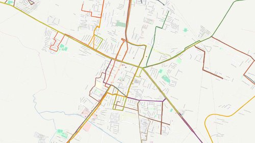
Image: All routes (43) were mapped in Zamora.
Impact on the Mobility Department
While the main goal was to ensure the accuracy of public transport data, Daniel has noticed that collaborative mapping tools open up a broader range of possibilities. These tools make it possible to carry out detailed studies of the mobility system, including accessibility and gender approaches.
The Mobility Department plans to keep using these tools for more specific purposes, starting with experiments in Mapillary to provide street-level imagery. The effort will begin in key areas of the city center and gradually expand to improve the overall understanding of public transport and how it interacts with public space.
Daniel highlights the support of the Mayor of Zamora, Carlos Soto, and the Director of Mobility, Rosendo Farfán, who recognize the importance of these projects even when they are not always visible. The Mobility Department considers generating accurate data essential before moving forward with decision-making. Open mapping tools are key to generating evidence and informing decisions and investment in the works that citizens need.
The team recognizes the importance of collaborative mapping for improving public transport, with a particular focus on care-related trips, accessibility for persons with disabilities and children's mobility. These are priorities for the department and the municipality.
Having started with OSM Tracker, the project will now move toward greater integration of Mapillary, with the aim of deepening and expanding the available database of street-level imagery. This will help address the lack of transport information and support more efficient management of municipal resources to better serve the population. This data will be integrated into Zamora's upcoming Comprehensive Sustainable Urban Mobility Program, helping to feed key indicators for actions to improve mobility as a whole.
Rosendo Farfán, Director of Mobility, says: "Implementing a Comprehensive Sustainable Urban Mobility Plan (PIMUS) requires a comprehensive, participatory approach. We believe the solution for cities lies in public transport, and our goals are to improve quality and efficiency, reduce congestion, increase accessibility and increase multimodal trips. It is important for us to highlight that, for the first time in our municipality, we have a clear route map and indicators on frequency, schedules and fares, all thanks to the data we carefully collected over these months of work."
This data, complemented by information on demand, the economy, environmental impact and infrastructure, will reveal mobility patterns and users' needs and preferences. This information will support the implementation of projects aimed at improving urban mobility. Collaboration between the Michoacán State Transport Institute, local transport operators and the municipality will also be strengthened, cross-referencing existing information with the newly collected data to optimize the city's public transport and make it efficient, modern and high quality for its users.
Share